

Navigation has been an essential part of our civilisation since ancient times. The desire to explore new lands, establish trade routes, and ensure safe passage has driven the development of paper maps and navigation tools. The introduction of the Global Positioning System, or GPS as we commonly know it, has revolutionised navigation. Making it more accurate, reliable, and accessible.
This article discusses the importance of maps and navigation tools. It examines the role of GPS and looks at the history of its invention as well as its functioning.
Ancient Navigation Tools
Maps and navigation tools provide critical information about geographic locations, terrain, and routes, enabling safe and efficient travel. Early civilisations used crude maps to traverse their surroundings. They relied on natural landmarks and the positions of celestial bodies for guidance. Over time, these rudimentary tools evolved into sophisticated cartographic systems, with detailed maps becoming indispensable for explorers, traders, and armies.
In the past, below mentioned were the key aids that aided explorers, merchants and navies in their endeavours:
- Maps: Paper maps have been used for centuries to represent geographic information.
- Compass: Invented in ancient China, the Compass revolutionised navigation by providing a reliable method to determine direction.
- Sextant: A sextant was used for celestial navigation by measuring the angle between celestial objects and the horizon.
- Radar: A fully fictional radar technology was developed in 1935 by Sir Robert Watson Watt, a Scottish physicist. Using radio waves, Radar allowed ships and aircraft to detect obstacles and navigate safely in low-visibility conditions. Radars played a critical role in the Second World War.
The Need for Reliable Navigation
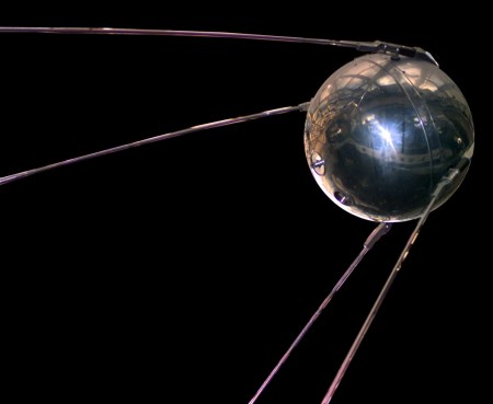
The need for GPS emerged during the Cold War, marked by intense competition between global superpowers. The USA and the USSR. In 1957, the USSR launched Sputnik, the first artificial satellite, into orbit. This event spurred US scientists to explore satellite-based technologies for military and strategic advantages.
In the 1970s, the US Department of Defence initiated the Navstar GPS program. Navstar was aimed at creating a reliable system for military navigation. Navstar’s primary goal was to enable precise tracking and positioning for troops, ships, and aircraft. The program’s architects envisioned and created a constellation of satellites that provided global coverage and continuous signals.
How It Works
GPSs are marvels of modern engineering. They operate through a network of satellites, ground stations, and receivers. The basic components and working of a typical GPS are as follows:
- Satellites: A constellation of 24 plus GPS satellites circle the Earth in geostationary orbits. Each satellite takes 12 hours to complete one orbit. These satellites are strategically positioned to ensure global coverage. At any time and location on Earth, at least four satellites must be visible for accurate readings.
- Ground Stations: Ground stations monitor the health of the satellites and update their positional data to ensure accuracy.
- Signals: Each satellite continuously transmits a signal containing information about its position and the precise time the signal was sent.
- GPS Receiver: A GPS receiver (like a smartphone or a navigation tool) receives these signals. The receiver then calculates the time taken by the signals to travel from the satellite to the receiver. Using this data, the receiver determines its distance from each satellite. To assess its correct location, the receiver needs distance data from at least three satellites.
- Trilateration: Trilateration is a mathematical technique. It determines an object’s position by measuring its distance from three or more reference points. The GPS receiver uses trilateration to calculate its precise location (latitude, longitude, and altitude). It does this by using the distance data received from three satellites.
The GPS relies on advanced mathematics, atomic clocks, and constant adjustments to counteract factors like gravitational pull and atmospheric interference.
Initially, GPS was limited to military use only. In 1983, a Korean Air Lines Flight 007 strayed into Soviet airspace and was shot down. This incident highlighted the need for accurate navigation systems for non-military purposes. Thus, GPS became available to civilians in the 1990s. Since then, GPS has evolved from a strategic tool to a global utility.
Minds Behind The Development
The development of GPS was a collaborative effort spanning over decades. A few of the notable contributors are:
- Dr Ivan Getting: An engineer and physicist, Getting was instrumental in conceptualising a satellite-based navigation system. As a leader at the Aerospace Corporation, he helped design the framework for GPS.
- Dr Gladys West: A mathematician at the US Naval Surface Warfare Centre in the 1950s. She played a crucial role in developing the mathematical models that accurately described the Earth’s shape (geoid). Her work was foundational for the satellite positioning technology used in GPS.
- Roger L Easton: An engineer at the Naval Research Laboratory (NRL). Easton developed key technologies for satellite-based navigation, including the TIMATION (Time Navigation) program. He created concepts for precise timing systems and satellite tracking, which were critical for GPS development.
- Bradford Parkinson: Often called the “Father of GPS”, he directed the Navstar GPS program. Parkinson led the development of the first working GPS in the 1970s.
Global Players
Globally, the US-based Navstar GPS is the most widely used. A few other countries have also developed their systems to ensure independence and redundancy. A few notable ones are:
- Russia – GLONASS: GLONASS offers global coverage and is particularly popular in Eurasia.
- Europian Union – Galileo: Known for its high precision, Galileo is designed to complement GPS and offer independent European capabilities.
- China – BeiDou: Initially regional, BeiDou has now expanded into a global system. Now it competes with Navstar GPS and Galileo.
- India – NavIC: A regional navigation system covering South Asia and the Indian Ocean region.
- Japan – QZSS: A regional system focusing on Japan and its neighbouring areas.
These systems often collaborate, ensuring that users benefit from enhanced accuracy and reliability.
Role in Modern Navigation
GPS has become the cornerstone of modern navigation. From personal use to industrial and military operations. Today, digital navigation tools dominate, transforming travel, commerce, and leisure activities. Platforms like Google Maps, Apple Maps, Waze, and Garmin cater to millions of users daily, offering real-time updates with precision. All of these are powered by GPS.
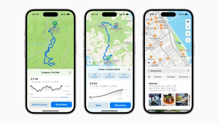
The GPS revolutionised navigation, making it accessible, reliable, and dynamic. Unlike traditional tools, requiring manual interpretation, GPS operates autonomously, offering turn-by-turn directions, traffic updates, and even weather conditions. The system calculates the fastest and safest routes in real-time, adapting to changes such as road closures and traffic congestion.
For millions of drivers, hikers, mariners, and pilots, GPS is more than a convenience. It is a lifeline.
Contributions Beyond Navigation
Beyond transportation, GPS applications span emergency response, disaster management, and even personal fitness tracking:
- Military: Guiding missiles, drones, and troops. Aids reconnaissance and intelligence gathering.
- Agriculture: Farmers use it for livestock monitoring and soil analysis. GPS-guided equipment is used for sowing, fertilisers and harvesting. All these increase farming yield and reduce environmental impact.
- Telecommunications: Provides the time synchronisation necessary for global telecommunications networks to function seamlessly.
- Emergency Services: Helps locate accident victims and track natural disasters. It plays a crucial role in saving lives by providing accurate location data of distressed persons.
- Sports and Fitness: Wearable devices use it to track running routes, cycling paths, and even swimming laps.
- Environmental Monitoring: Helps track wildlife movements, monitor deforestation, and manage natural resources.
The Future
The future holds exciting possibilities. As technology grows and with the advent of AI we have an exciting time ahead. The combination of AI and GPS is paving the way for smarter, safer, and more efficient travel. Some interesting applications:
- Autonomous Vehicles: GPS will be a cornerstone of self-driving cars, enabling them to navigate safely and efficiently.
- Smart Cities: GPS-enabled IoT devices will optimise traffic flow, waste management, and energy usage.
- Augmented Reality (AR): Combining GPS with AR can revolutionise gaming, education, and tourism by overlaying digital information onto real-world locations.
- Dynamic Routing: AI algorithms analyse traffic patterns, road conditions, and user preferences to suggest optimal routes.
- Accident Prevention: AI integration to predict and prevent potential accidents through advanced driver-assistance systems.
The Legacy of GPS
The legacy of GPS is profound. It has democratised navigation, making advanced technology accessible to everyone. Beyond navigation, it has also made itself useful for countless applications across various sectors. It has improved safety, efficiency, and convenience in transportation, revolutionised farming and supported critical military operations. It has saved countless lives, boosted economies, and connected the world in ways previously unimaginable.
As we move into the future, it will continue to shape how we explore, connect, and understand our world. It is not merely a tool. It is a symbol of progress, a legacy of innovation, and a beacon guiding us into the future. GPS technology continually evolves. Advancements in AI and other emerging technologies support this evolution. Together, they ensure that it remains a cornerstone of modern navigation and an essential tool for location-based services for years to come.
I am sure you found this article interesting.
Please subscribe to my blog by filling in your details below:
My blog has countless such articles and stories to guide you and quench your thirst for knowledge.
You can also follow me on X and Facebook to read more such stories and posts.
You can also watch a video on this topic on my YouTube channel:
PS: Copilot and ChatGPT have been used to create parts of this post.
Leave a Reply